The Ministry of Defence (MOD) is one of the UK’s largest landowners, owning some of the finest rural landscapes in the country. But should it lead by example with a drive for greater access, or is the real purpose for holding MOD estate simply for training in defence of the nation? Air Commodore Nick Kurth from MOD Defence Estates lifts the lid on this difficult issue.
In reality there is a fine balance, and access to the MOD estate is firmly biased in favour of the public - wherever it is compatible with military and operational training needs, safety, security, conservation and the interests of the MOD’s tenants.
And in order to ensure that the bias is maintained when set against this rather long list of constraints, access has to be managed, monitored, and in some cases controlled.
Personally, I have a nightmare with this balance. On the one hand, I am a keen but moderately talented rock climber (my Classic Rock book is well thumbed) and a stalwart member of the RAF Mountaineering Association, leading to the “just why can’t I go climbing there?” argument. On the other hand, I’m a member of the MOD Defence Estates Agency and MOD Advisor to the BMC Access and Conservation Group, tending towards the “Access must be compatible with military and operational needs” line. However at least I’m well placed to give an overview of where we are on this potentially difficult issue. So hold tight for a tour - and I look forward to any future debate!
Access to the countryside has moved up the political agenda over the past few years and we hope that the MOD has risen to this challenge by managing public access in a positive and proactive manner. Locally, access is managed by Service personnel and Defence Estates’ staff, in conjunction with contractors, local councils, interest groups and others. And at a number of specific sites, such as Otterburn and Castlemartin, staff have been appointed to manage access opportunities. Then at a national level within Defence Estates Martin Coulson, responsible for land management policy and Richard Brooks, the Access and Recreation Advisor have worked with statutory bodies and non-governmental organisations to develop a strategy on access and recreation.
As I’m sure you’re aware, the CRoW Act has had a large impact in England and Wales, setting out to give the right of access on foot to mountain, moor, heath and down. A massive mapping and appeals exercise took place and the resulting maps depicted areas meeting the criteria for access land. But, in practice there are a number of exceptions to access, and areas covered by Military Bylaws is one. It was apparent right from the start of this legislation that whilst large parts of the Defence estate were CRoW mapped, large areas would also be excluded for reasons of safety and security.
In some areas there were no issues due to the benign nature of the military activity, and access was put in place with the regional rollout programme - such as parts of the Otterburn and Warcop Training Areas. But in a number of cases open access was just not compatible with the military activities taking place, and a formal process using the CRoW Act provisions has been put in place to validate these cases. Our policy has been to keep such instances to an absolute minimum. In contrast to the need to restrict access we have devised - with the Ordnance Survey - a new map symbol highlighting managed access to compliment the existing danger area symbol. See this handy example:
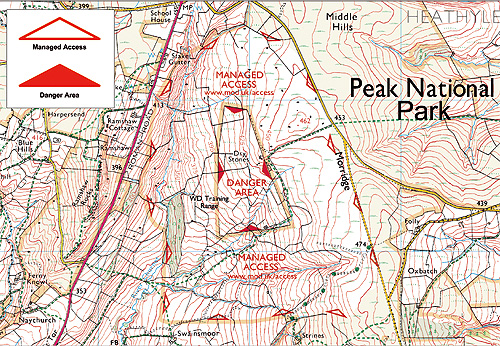
Managed access areas are sections of MOD land which have significant access opportunities but where access maybe restricted either at times or to certain routes. The maps not only show the extent of these areas but also give website addresses and/or telephone numbers, so that the specific details can be determined. Danger areas are those segments of land that have either no access arrangements or offer limited opportunities.
Turning to North of the border, the access legislation is further reaching. Having come live on the 9th February 2005, Part one of the Land Reform (Scotland) Act 2003 allows for most recreation on, over and under land, and inland water. Scottish Natural Heritage has put the emphasis firmly on responsible behaviour by both the public and land managers, by issuing a Scottish Outdoor Access Code. Within this code, Military lands are described and the public is warned to take heed of notices and directions on sites, including red flags. They are warned not to touch suspicious objects and to be aware of sudden noises. The public is excluded from areas where red flags are flying because of the dangers caused by live firing or other associated risks, but at other times may enter the land. Access management under this legislation is still in its infancy and we will be learning a great deal over the short term about both responsible access provision and responsible behaviour by the public.
Ultimately, the MOD is committed to working towards delivering the bias in favour of public access, where this is possible, and is striving to achieve better quality and greater public access opportunities. However, it is a balancing act, and for every satisfied “customer”, I’m sure there are several that are not. But I can assure you that many individuals within the MOD hope to see you out on the moors and crags of the Defence estate - and you’ll find one of them in particular out there climbing himself!Case Case
Case study:Otterburn
Covering some 58,000 acres, Otterburn Training Area is the second largest Army Training Estate in the UK. Chris Livsey, the Otterburn Ranger gives his view.
In 1956, Otterburn was included as part of the Northumberland National Park and represents one fifth of its overall area. A public right of way network extending to over 200km and almost 5,500ha of CRoW access land makes Otterburn one of the most accessible training areas in the country. Military training can be traced back as early as the Romans with famous marching camps such as Chew Green providing shadowy footprints in the landscape. Predominantly an artillery range, modern military training commenced in 1911 and Otterburn is now recognised as a strategic training location for artillery systems.
Access to the danger area is controlled by Military Bylaws. Public notices indicate when live firing is taking place and this is indicated on the ground by the flying of red flags (or lamps during darkness) at public entry points. However the dry training area (no live firing) to the north of the River Coquet is not subjected to Military Bylaws and access is available all year round. This is the best area to take in a days hill walking (Explorer map OL16) - starting from the villages of Alwinton or Byrness to the West, it’s not long before you are experiencing true solitude. The Pennine Way creeps along the Northern boundary of the training area and old drovers roads such as Clennell Street are reminders of the area’s strong trading routes. The weather can be glorious but watch out for that cloud coming in!
Based at Otterburn Camp, I look after the area’s access and recreation opportunities and provide advice to both the military and public. Also, and probably more challenging, I work with my colleagues to integrate access aspirations of all stakeholders into the MOD’s requirements without compromising the primary Defence objective. I believe that there are fantastic opportunities here at Otterburn and, as many of the local users will testify, the minimal extent of military activity in this part of the training area doesn’t detract from their experience in any way.
Chris Livsey
Case study: Castlemartin
One of the most famous areas of MOD land is Castlemartin - Ranger Lynne Ferrand has the details.
Access to the MOD area at Castlemartin has had a murky past. Prior to 1990, Range West was essentially a “forbidden” place for climbers - out of bounds, owing to unexploded ordnance. This created a certain illicit appeal and the site was visited secretly, sometimes resulting in climbers being escorted from the site.
However, following an organised trespass by local climbers, fresh talks began. An agreement in 1992 between the BMC, MOD and members of the South Pembrokeshire Range Recording and Advisory Group (which includes the Pembrokeshire Coast National Park Authority and the Countryside Council for Wales) led to climbers being allowed access onto Range West between mid-August and the end of January. Climbers attend an annual briefing, where they are informed about military, conservation and, health and safety issues, and are supplied with an access permit.
The opening dates were originally chosen in order to protect the cliff-nesting birds from previously unknown human disturbance - they were used to the military disturbance. The Castlemartin cliffs and dunes are designated a Site of Special Scientific Interest, amongst other protective acknowledgements, due to the variety of rare and protected species and the range of habitats. Since this time, the working partnership has gained strength and access for climbers has improved. And following proposals from the BMC:
- In 2002 Access was brought forward to the 1st August, and entry onto Range West from Gupton Gate was available for the first time
- From August 2003, the MOD allowed one briefed climber to take an unbriefed climber
- Access was brought forward to the end of May in 2004
- Climbers can now book on during office hours rather than the previous limited opportunities
My jointly funded post came into being in 2003 and I believe it’s assisted the management of wider opportunities for access as a consequence. Although this possibly sounds one-sided with only climbers benefiting, this is not the case. Climbers are often the conservationists’ “eyes and ears”, as they see the cliffs from closer proximity - they often provide information about new or changed nesting sites or where they have seen seal pups. The local BMC rep also assists by ringing chough on the Range, enabling this relatively rare species to be monitored.
Briefings for climbers are held three times per year at Castlemartin Camp, although the number of climbers attending these briefings and accessing Range West has decreased over the last two years.
This may be due to the large difficulty factor - high exposure, loose shale and erosion on the cliff tops. The BMC is proposing the installation of stakes for belaying. Meanwhile I’m working with the other authorities to place red cliff top markers to identify climbing restriction areas to protect the nesting birds. Laminated maps are also produced and issued to climbers when they sign on at the range - they highlight the restricted areas and related timescales. Lastly, an annual liaison meeting is held to discuss conservation, safety and climbing issues, which involves representatives from all the agencies involved.
Lynne Ferrand
Don't forget: Walks on Ministry of Defence Lands
Amazingly, MOD land contains over 1300 km of Public Rights of Way, with at least another 200km of permissive paths or bridleways. And much of this land is some of the finest in the UK, including National Parks, Areas of Outstanding Natural Beauty, National Scenic Areas and Heritage Coast. To help spread the word, walking opportunities have been detailed on the MOD Access website . This covers walks at Garelochhead, Castlemartin, Sennybridge, Catterick, Dartmoor, Longmoor, Lulworth, Otterburn, Salisbury Plain, plus others. The publication of routes for climbers for areas such as Pembroke is being discussed with the BMC.
« Back